By Rocky Mountain Complex Incident Management Team 2
A portion of the previous evacuation order west of the fire area has been elevated to Go status. This includes the area south of Highland Rd. west of Hwy. 20 heading east back to Cottonwood Rd. as a result of strategic firing operations underway near the intersection of Hwy. 20 and Cottonwood Rd. Due to this, Hwy. 20 will be intermittently closed. Please be aware that closures may happen due to fire activity along the highway.
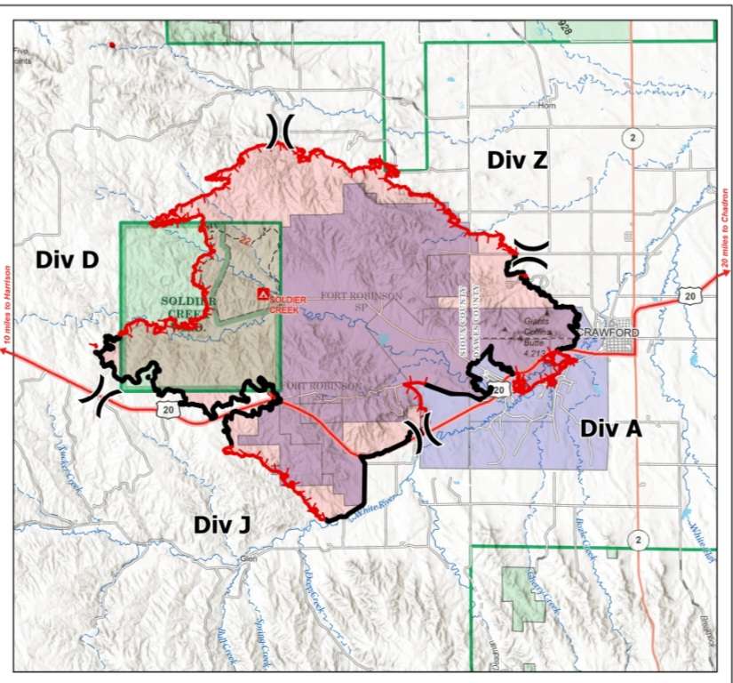
Current Conditions: Containment has jumped to 42%, while southwest winds increased fire activity on the north edge of the fire. The fire is now 32,818 acres with approximately 496 personnel assigned. The shifting wind conditions moved the fire yesterday to the north and east in the morning. Last night the wind shifted out of the northeast and pushed the fire to the west toward Cottonwood Road on the west side in Division Delta. Crews will be evaluating this area to find opportunities to contain the fire south and east of Cottonwood Road. Values at risk in this area have been identified and priorities continue to be on firefighter and public safety. Aviation assisting crews on the ground have contributed to strong containment lines in Division Zulu on the northeast section of the fire. Aircraft dropped 42 loads of retardant for a total of 170,000 gallons while scoopers made 36 water drops for a total of 58,000 gallons. A unmanned aircraft system (UAS) with infrared capabilities gathered heat signature data on interior pockets of fuel. Around the community of Crawford and Fort Robinson the fire activity is minimal and the containment is in this region of the fire.
Weather and Fire Behavior: Weather conditions are changing across the incident as an approaching cold front arrives, reducing temperatures by as much as 20 degrees and boosting relative humidities. These changes are expected to lower fire activity in most areas of the fire except in Division Delta on the northwest, due to the fuels there. Breezy winds will begin out of the northeast. Interior pockets of heat will continue to burn with creeping and smoldering in some areas.
Evacuations and Closures: All previous evacuation orders are still in place including:
- White River Trail is closed from Crawford City Park to Fort Robinson.
- Go Status: Fort Robinson State Park and a portion of the city of Crawford. The evacuation area includes locations immediately north of Crawford, including areas south of Dodd Road, west of Dodd Road, and Dodd Road at Holmgren Road and the Ponderosa Villa assisted living facility. See also the header above.
- Set Status: The city of Crawford. Residents west of Toadstool Road to Milford Road and south of Sand Creek Road and north of Cottonwood Road. June 13, 2026 Region 23 Emergency Management issued the following evacuation notice: The area north and west of the fire from Toadstool Road west to Orella Road to Hat Creek Road to Pants Butte Road down to Highway 20 are now in Set status excluding the new area in Go status as referenced above. “Set” means residents should be aware of the fire activity in their area and have a plan to evacuate if conditions change.
- Ready Status: Residents north of Crawford and south of Forest Service Road 928 west of Highway 2, to Toadstool Road.
22 structures and 95 people are under active evacuation orders. The Red Cross established community shelter options at Chadron State College–Andrews Hall and is supporting shelter operations. A preliminary evacuation notice has also been issued for the entire city of Crawford. Residents are encouraged to prepare for the possibility of evacuation. For guidance on how to prepare, visit Ready.gov.
Air Quality - An Air Quality alert has been issued for Dawes county from 12 a.m. Sun. through noon Monday associated with the South Fork Fire. The forecast indicates low windspeeds and the potential for elevated PM2.5 levels in this area. For more information visit forecast.weather.gov. Nebraska air quality information: https://dwee.nebraska.gov/smoke-and-air-quality. Air Quality Guide: Air Quality Guide for Particle Pollution
Temporary Flight Restrictions (TFR): tfr.faa.gov The South Fork Fire is currently under a TFR. Please respect the fight restrictions including drones and unmanned aircraft systems. These pose a significant risk to our aviation safety.